

Preview
Creation Date
2014
School
School of Communication and Arts / Centre for Research in Entertainment, Arts, Technology, Education and Communications
Keywords
Reimagining Perth's Lost Wetlands, Perth, history, Gabbi Darbal wetlands, environment, digital modelling
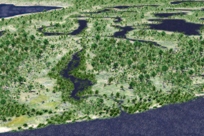
Description
This image was part of the Reimagining Perth's Lost Wetlands Exhibition displayed at the Perth Town Hall from 21 September to 9 October, 2014. The exhibition also included archival maps and botanical illustrations as described below:
Have you ever wondered what Perth was like before it was a city?
Welcome to Gabbi Darbal in 1827.
Like many other cities around the world, Perth was founded on wetlands. These environments have played a significant role in the city’s development, and are important habitats for a range of species. This project aims to raise awareness of the cultural and environmental importance of Perth’s wetlands.
This project includes three-dimensional digital modelling of Perth's lost wetlands based on:
- archival maps;
- geological soil mapping;
- vegetation complex mapping;
- botanists' and early settler's accounts of the flora;
for the Claise Brook catchment from Herdsman Lake to the Swan River.
Rights
This image is available under the terms of the Creative Commons Attribution 4.0 License. When reproducing it the following must be included in the attribution: Reimagining Perth's lost wetlands: Artistic impression of Perth as it may have appeared in 1827 (looking west from the Claise Brook entry to the Swan River across the lakes of central Perth). Copyright: Edith Cowan University 2014. Reproduced with the permission of Edith Cowan University, who wish to acknowledge research partners City of Perth and Landgate.
Creative Commons License

This work is licensed under a Creative Commons Attribution 4.0 License.
Keywords
Reimagining Perth's Lost Wetlands, Perth, history, Gabbi Darbal wetlands, environment, digital modelling